
NAVIGATION WITH COMPASS
 While biking sometimes you're standing in the desert on a road crossing and
there are too much choices where to go. And you look around for traffic signs,
but this time there are no signs, what to do?
While biking sometimes you're standing in the desert on a road crossing and
there are too much choices where to go. And you look around for traffic signs,
but this time there are no signs, what to do?
- Get you mobile phone and call you're mom,
- Wait till local people come and ask them,
- Be a real guy and get your compass.
Of course you chose number three, because real mom lovers stay at home
and you don't want to get killed by a local. But how to use that smart
little globe trotter tool. Read and practise the lesson below and you
never will be lost again.
Jump now to the next subjects:
- BASIC USE
- WHAT IS DECLINATION?
- LINKS
BASIC USE
The procedure below describes how you can reach your target by using a map and a compass.
- Place the compass on the map with the edge of the compass along the desired line of travel.
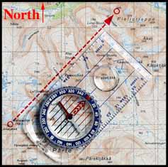
- Rotate the compass housing until N on the dial points North on the map. Check that the compass housing red/black north/south lines are parallel with the maps meridians.
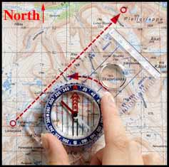
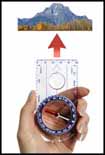
- Hold the compass in your hand and turn yourself until the red end of the compass needle (North) coincides with the red arrow in the bottom of the compass housing. The front of the compass with the direction of travel arrow is now pointing towards your destination.
WHAT IS DECLINATION?
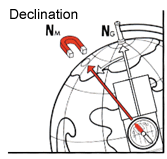 Now you're well trained enough to use the compass, but you still
can get lost. Most people think compass gives the direction of
the North Pole, but this is an mistake. A compass point to the
direction of the magnetic North, which is located somewhere in
North Canada.
Now you're well trained enough to use the compass, but you still
can get lost. Most people think compass gives the direction of
the North Pole, but this is an mistake. A compass point to the
direction of the magnetic North, which is located somewhere in
North Canada.
The difference between the real north and the north given by
the compass is called declination. When the declination is known
the real north can be calculated.
Definition
For West declination the angle is negative for East declination it is defined as positive.
How to compensate for West declination?
When you are in an area of west-declination (negative declination) you have to add the angle but possitive to compensate the compass reading.
So for -20° declination you add 20° to the compass reading to get the geographic north.
How to compensate for East declination?
When you are in an area of east-declination (positive declination) you have to subtract
the declination angle to compensate the compass reading.
So for +20° declination you subtract 20° to the compass reading to get the geographic north.
Declination example South Africa
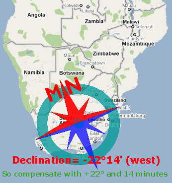
- Position:South-Africa (Lat/LOng=30S,25E at 1-1-2010)
- Declination= 22° 14' W deg (This means you have to compensate to the east.)
When your compass has a declination scale turn the declination scale to 22 deg west declination.
Then make sure the needle is inline with the 22 deg west declination scale, now your compass points to the geographic north.
 You can find this declination scale at the inside of the degree scale (red). At the left is
written W-decl (West-declination), and at the right E-decl (East-declination). A red arrow is painted on the
scale as well this indicates the direction of the magnetic north.
You can find this declination scale at the inside of the degree scale (red). At the left is
written W-decl (West-declination), and at the right E-decl (East-declination). A red arrow is painted on the
scale as well this indicates the direction of the magnetic north.
DECLINATION CHARTS
To make it more complex the declination is not constant,
it differs from time to time and depends on the place where you are.
By using the next charts you can find the declination of the place where you are.
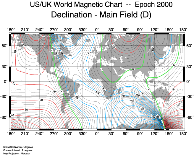
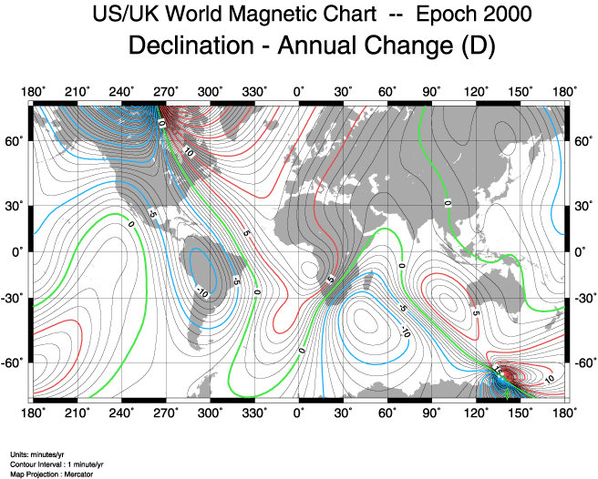
Note: The annual change is given in minutes per year! One minute equals 1/60 degree.
Declination in Amsterdam 1900 - 2010
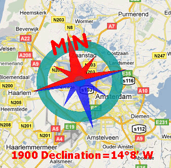 On the left you can see the variation of the declination over time for Amsterdam. People living in
western Europe experience hardly no declination today but in 1900 this was quite different.
On the left you can see the variation of the declination over time for Amsterdam. People living in
western Europe experience hardly no declination today but in 1900 this was quite different.
Additional information on the internet see: